

Feature

Smart Zoom
Smart zoom offers a large improvement over standard zoom functions.
While driving the route: When approaching an intersection, the screen is enlarged and the viewpoint raised so that you can easily see which way to drive at the next intersection. After navigating the intersection, the screen is reduced and the angle lowered to check the road in front.
When driving without route navigation: The screen is enlarged as you slow down and reduced as you speed up.
Switching between Day and Night Screens
For the Map screen and menu screen, the colours differ between day and night.
During daytime, the screen's colours are the same as those of a printed map, and the menu is brighter.
At night, the screen uses dark colours for large objects and reduces the overall brightness of the screen.
The screen's colour scheme differs between day and night. Using the current time and GPS position, you can also switch automatically between day and night screen settings just before sunrise (at dawn) and just after sunset (at dusk).
Screen Design in Tunnels
When you enter a tunnel, the map colours change. All buildings disappear, and large objects with nothing between roads (lakes, seas, forests, and so on) turn black.
However, roads are displayed as they are whether the screen is currently using day or night settings.
When you exit the tunnel, the original colour scheme is restored.
Route Search/Search Again
You can search for routes to suit your preferences.
Route search methods:
 :
:
Searches all roads for the quickest route following the speed limits of the roads.
 :
:
Searches for the route that conserves the most energy, taking into account the merits of “Fast” and “Short”.
 :
:
Searches for the shortest distance in all possible routes.
 :
:
Searches for a route that is easiest to drive, with few right and left turns. Using this option, the program allows you to avoid combinations of smaller roads and to take the motorway.
Search for a route by using or avoiding certain road categories:


When data is available, a route is searched for based on prior statistical data relating to the day, week, and time. Online Road Information Saved in Route Search
The route may change drastically when real-time traffic conditions are factored in.
If you leave the route that was searched for based on your current position, and new information is received regarding traffic conditions for the recommended route, the software automatically searches for another route.
See Route Settings for detailed information on Route settings.
GPS Positioning Quality Indicator
The GPS reception quality icon at the top right of the menu screen indicates the current accuracy of positional information.
Icon | Explanation |
|---|---|
| The software is not connected to the GPS receiver. Cannot perform GPS navigation. Products with a built-in GPS receiver are always connected. This icon is not normally displayed for those products. |
| Although the software is connected to the GPS receiver, the signal is too weak to measure the GPS. Cannot perform GPS navigation. |
| Only a few satellites are transmitting. Positional information is available, but altitude (elevation above sea level) cannot be calculated. GPS navigation is possible, but large positional errors may occur. |
| Elevation above sea level is available, and measurements can be performed in 3D. GPS navigation is available. |


Online Road Information Saved in Route Search
The recommended route between two points is not always the same. Even when offline, statistics on traffic information (prior traffic data or traffic patterns) are gathered in the main unit, and when data is available, a route is searched for taking into account statistics relating to the day, week, and time. Additionally, real-time traffic information (TMC) is also available, allowing you to avoid traffic jams due to temporary road closures or accidents. This has an impact on any function for which data is available.
Smart route using traffic information in saved statistics
When statistical information is included in map data, the information can be taken into account when searching for a route. This function is normally useful for avoiding traffic jams that usually occur on regular weekdays, however errors may occur if a national holiday and so on falls on a regular weekday. In situations like that, you can turn off Smart route from Traffic settings. Traffic
Real-time traffic information (TMC)
Unlike the statistical traffic information TMC (Traffic Message Channel) offers real-time traffic conditions. This can help you to avoid traffic jams that could not be anticipated due to road closures or accidents.
TMC uses a dedicated FM Radio Data System (RDS) to broadcast real-time traffic and weather reports.
The default settings use traffic information when searching for a route.
The TMC receiver necessary to receive traffic condition reports is built-in to some products, but not for others. Contact your nearest dealer.
If traffic data normally broadcast in your region can be accessed, this received information is automatically taken into account. This does not need to be manually set. FM radio stations broadcasting TMC data are searched for automatically, and decoded information is immediately used to search for routes. If traffic information that might affect the current route is received, a warning is displayed indicating that the route will be searched for again, and navigation continues using a new optimal route taking into account the latest traffic conditions.
By delaying the timing before applying a route that has been searched again, the user can check the route and fine-tune the details creating the optimal search results. You can set this from Traffic settings. Traffic
When traffic information is being received,
a special icon ( ) is
displayed on the map. When there is no traffic information available
for the route, this icon indicates the status of the traffic information
receiver, and when information is received, the type of upcoming traffic
information is displayed.
) is
displayed on the map. When there is no traffic information available
for the route, this icon indicates the status of the traffic information
receiver, and when information is received, the type of upcoming traffic
information is displayed.
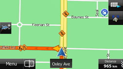
Road sections affected by traffic conditions are displayed in a different colour on the map, and a small icon representing the type of traffic condition is displayed above the road.
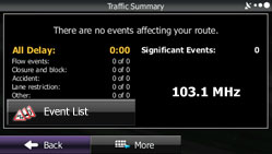
Touch  to display the Traffic Summary screen.
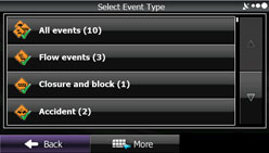
Touch  to check the traffic information that
has been received.
to check the traffic information that
has been received.
On this screen, you can select one entry from the list to view list of the traffic conditions for that section of the road.
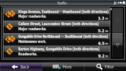
On this screen, you can select one entry from the list to view full details of the traffic conditions for that section of the road.
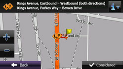
Touch  to open another screen displaying information
on the selected map position.
to open another screen displaying information
on the selected map position.

This function is only available when TMC is installed in the product being used.
The TMC service is not available for all regions. There are also times when it may not be available in your country or district. For more information on availability, contact your nearest dealer.